Storm Queenie Nears Typhoon Strength, Threatens Okinawa
Severe Tropical Storm Queenie, known internationally as Surigae, is forecast to become a typhoon as it moves through the Philippine Sea toward waters south of Okinawa, according to Philippine and Japanese weather services.
Listen to the story
Short version
Storm Queenie (Surigae) is nearing typhoon strength and heading toward Okinawa and Japan, while regional experts meet to improve typhoon forecasting.
- Queenie forecast to become a typhoon near Okinawa
- Storm expected to exit Philippine area, then weaken after Sept 28
- Reported wind speeds varied between 110 kph and 185 kph gusts
- China-Southeast Asia forum in Bangkok addressed forecasting challenges
- Joint Thailand-China system previously aided a 2018 Phuket rescue
What's new
- Queenie intensified further as it neared exit from the Philippine Area of Responsibility
- PAGASA expects typhoon strength by Saturday
- Storm is forecast to accelerate toward Japan and strengthen near Okinawa
- Regional experts met in Bangkok to discuss typhoon forecasting challenges
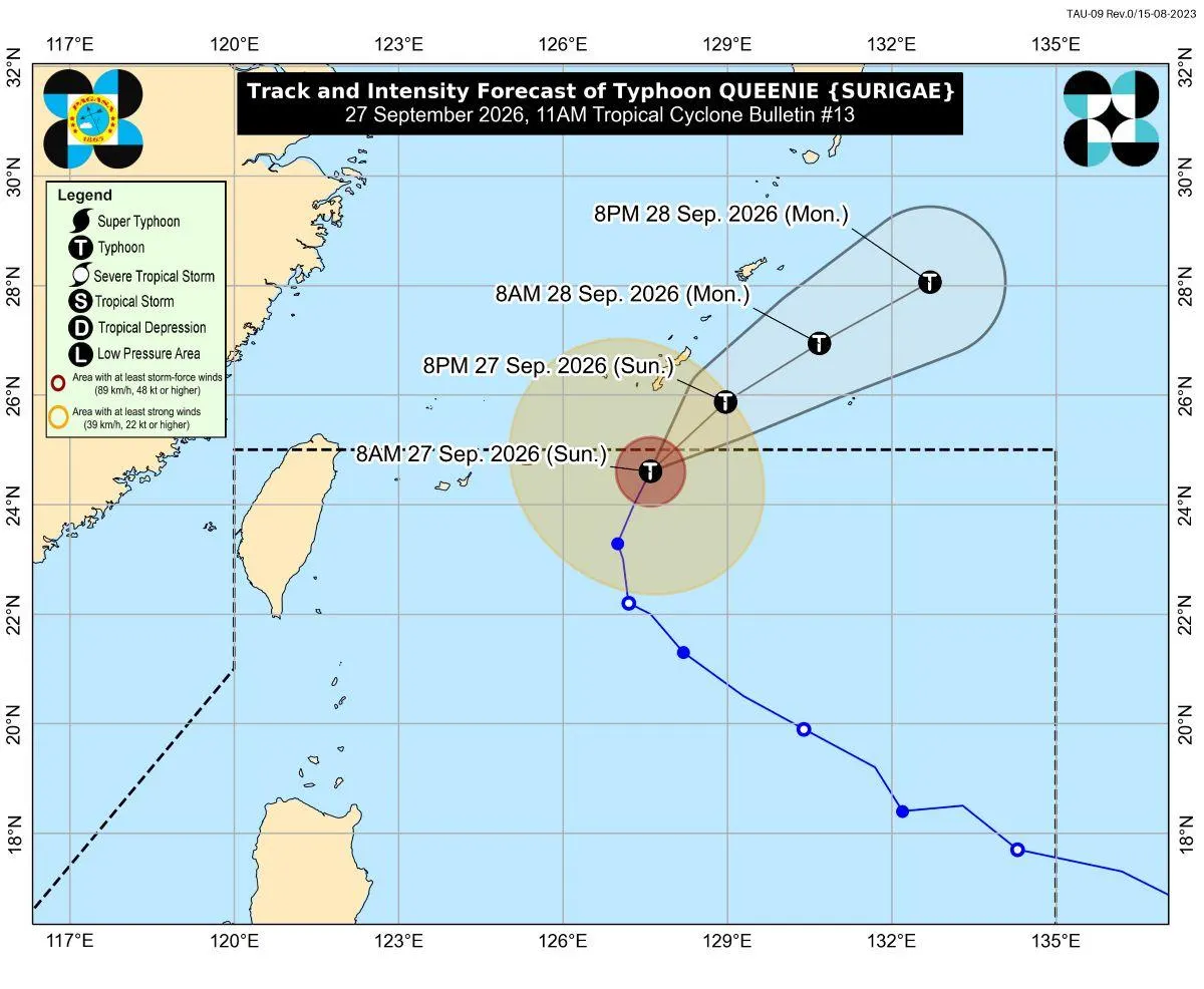
Severe Tropical Storm Queenie, internationally named Surigae, was nearing typhoon strength over the Philippine Sea as of September 26, 2026, with the Philippine weather bureau PAGASA and Japan-focused forecaster Weathernews both projecting further intensification as the storm tracks toward waters south of Okinawa.12
Storm track and intensity
According to PAGASA, Severe Tropical Storm Queenie was moving west-northwestward at 10 kph over the Philippine Sea, with maximum sustained winds reported near 110 kilometers per hour and gusts of up to 135 kph. The bureau placed the storm's center roughly 575 kilometers east-northeast of Itbayat, Batanes, and said strong to storm-force winds extended outward up to 280 kilometers. No tropical cyclone wind signal was in effect, and PAGASA said Queenie was unlikely to directly affect Philippine land areas during the forecast period, though moderate seas of up to two meters were expected off Isabela, northern Batanes and eastern Davao Oriental.1
By the following day, PAGASA reported that Queenie had slightly intensified while accelerating north-northeastward at 15 kph, with gusts reaching up to 160 kph. GMA News Online, citing PAGASA, reported that Typhoon Queenie kept gaining strength as it approached the boundary of the Philippine forecasting zone, with gusts climbing to as much as 185 kilometers per hour. PAGASA said the storm was forecast to leave the PAR between noon and afternoon.14
PAGASA said: "Outside the PAR, it will accelerate northeastward towards the sea south of mainland Japan," adding that the system would continue gaining power as it crossed the waters south of the Okinawa Islands, and that Queenie would start losing strength the day after reaching its highest intensity, expected around September 28.4
Weathernews forecast Tropical Storm No. 26 (Surigae) would strengthen into a Severe Tropical Storm with sustained winds of 50 knots by 15:00 UTC on September 25, then reach typhoon intensity by 00:00 UTC on September 27 with a central pressure of 975 hPa. The outlet projected peak intensity between September 28 and 29, with pressure deepening to 955 hPa and sustained winds reaching 80 knots, before the storm was expected to remain a powerful typhoon through September 30 with pressure of 965 hPa and winds of 75 knots. Gale-force winds were said to already extend up to 150 nautical miles north and 90 nautical miles south of the center, with storm-force winds forecast to expand to a 95-nautical-mile radius by 03:00 UTC on September 26.2
Weathernews noted that the storm's name, Surigae, was submitted by North Korea for use on the region's shared list of tropical cyclone names covering the western Pacific and South China Sea, and that it refers to a type of eagle also called the black-winged kite or hawk.2
Regional cooperation on forecasting
CGTN reported that specialists from China and Southeast Asian nations gathered in Bangkok this week for the ninth edition of a marine cooperation forum linking China and Southeast Asia, drawing upwards of 200 delegates from over 40 marine agencies, research bodies and universities. The outlet characterized Southeast Asia as the planet's busiest typhoon zone, where cyclones threaten lives and livelihoods every year, and noted that forecasting how powerful a typhoon will become continues to rank among the toughest unsolved puzzles in climate research.3
Qiao Fangli, a researcher with China's First Institute of Oceanography under the Ministry of Natural Resources, presented forecasting advances at the forum and said, "China-Southeast Asia marine cooperation shows how science can serve people's well-being," adding that predicting a typhoon's exact strength remains a stubborn scientific hurdle and that unity is needed to protect the lives and property of people living along the coast.3
According to CGTN, a marine environmental forecasting system that Thailand built together with China helped guide search-and-rescue efforts when the Phoenix tour boat overturned near Phuket in 2018. Darika Sarunyagate, who advises Thailand's Ministry of Natural Resources and Environment, said, "Regional cooperation has become more important than ever." She added that she hoped the program would move past simply swapping information and experience, becoming instead a genuine platform for building tangible partnerships, discovering new avenues for collaboration and strengthening ties across the region. Pinsak Suraswadi, director-general of Thailand's Department of Marine and Coastal Resources, said his agency is dedicated to turning marine science findings into real-world governance actions.3
Why it matters
Weathernews' simultaneous tracking of storms across the Atlantic, such as Gonzalo near Cabo Verde and Fay in the central Atlantic, underscores that tropical cyclone activity is a global monitoring concern, not confined to the Pacific.23
Version history
- version 1 ·