Hurricane Polo weakens as it nears Mexico's Baja California peninsula
After explosive strengthening to Category 5 intensity, Hurricane Polo has begun losing power on its approach to Baja California Sur, where landfall is forecast around Monday.
Listen to the story
Short version
Hurricane Polo, which briefly reached record-level Category 5 strength in the Eastern Pacific, is weakening as it approaches Mexico's Baja California peninsula, with landfall expected around Monday, September 28.
- Polo's winds rose 110 mph in 24 hours, per Fox Weather
- Central pressure hit 892 mb, near-record for the basin
- Storm weakened from Category 5 to Category 3 by Saturday
- Landfall expected in Baja California Sur as weaker storm
- Evacuations, closures reported along Mexico's Pacific coast
What's new
- Polo weakened from Category 5 to Category 3 during Saturday, according to El Financiero
- Mexico's Meteorological Service issued an advisory tracking the storm toward Baja California Sur
- Evacuations, port closures and school suspensions reported along Mexico's Pacific coast
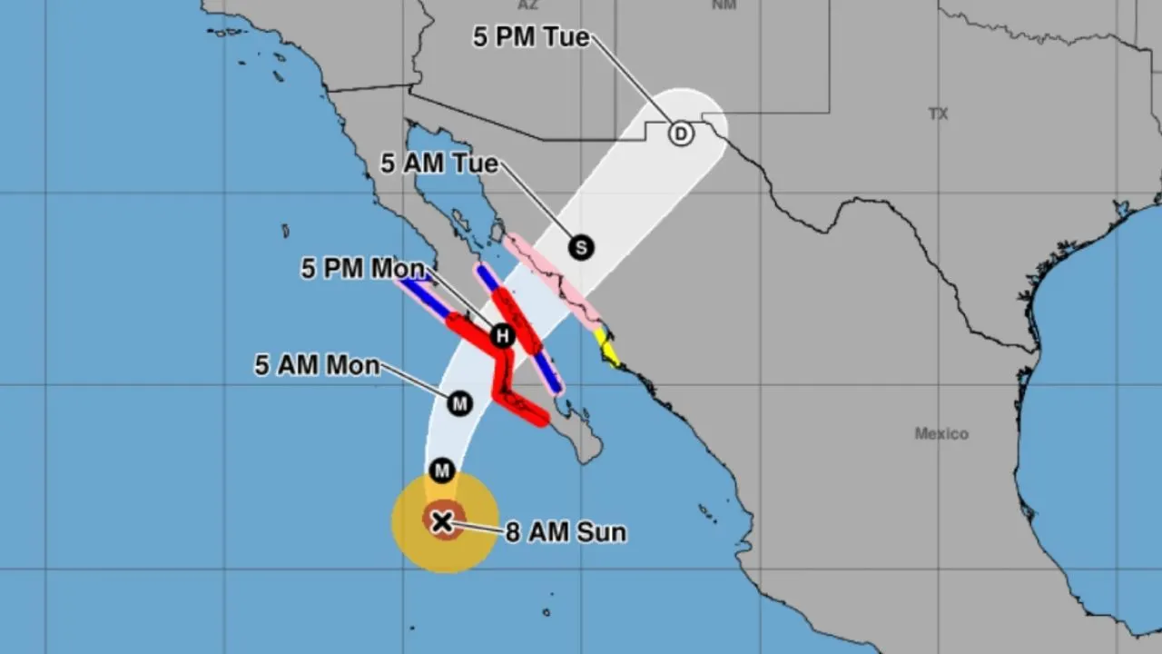
- Forecasters expect landfall as a much weaker Category 1 or 2 hurricane
Hurricane Polo, which underwent extreme rapid intensification in the Eastern Pacific and briefly reached Category 5 strength three times, was weakening as it moved toward Mexico's Baja California peninsula, with landfall forecast in Baja California Sur around Monday, according to Yale Climate Connections, Fox Weather, El Financiero and LatinUS.1235
Rapid intensification and record strength
According to Fox Weather, Polo's maximum sustained winds increased by 110 mph within 24 hours, a rate of strengthening the outlet described as the second-fastest ever observed in the basin.2
The storm's central pressure fell to 892 millibars. Yale Climate Connections reported this was the second-lowest pressure on record in the Eastern or Central Pacific, behind Hurricane Patricia's 872-millibar minimum in 2015.1
According to Fox Weather, just nine hurricanes since 1950 have registered pressures under 900 millibars, and Polo's wind speeds matched those of 2009's Hurricane Rick, placing it third among the strongest Pacific hurricanes ever recorded, trailing only Patricia's 215 mph in 2015 and Linda's 185 mph in 1997.2
Polo became the third Category 5 hurricane of the season in the Eastern and Central Pacific, Fox Weather said, noting the basin last produced three Category 5 storms in 2018. Yale Climate Connections reported Polo as the seventh Category 5 tropical cyclone recorded worldwide in 2026, above the 1990-2025 average of 5.3 such storms a year.21
Track toward Baja California
Polo was centered about 165 miles south of Zihuatanejo on Wednesday, with top sustained winds of 150 mph and estimated central pressure of 922 millibars, according to Yale Climate Connections. The storm's slow movement was linked to a sharp turn toward the northwest, and winds of hurricane force reached as far as 40 miles outward from its core.1
The FOX Forecast Center said Polo was expected to gradually lose strength over the weekend as it moved into an environment of colder ocean temperatures, stronger shearing winds and drier air.2
Mexico's Meteorological Service issued Advisory No. 38-26 at 18:30 local time on Saturday, September 26, tracking Polo's position and intensity. El Financiero reported the storm degraded from Category 5 to Category 4 during the day and to Category 3 by evening, with forecasters expecting landfall in Baja California Sur on September 28 as a Category 1 or 2 hurricane before weakening further to a tropical storm over Sonora and dissipating to a tropical depression over land.3
According to Yale Climate Connections, tropical storm warnings covered the stretch between Tecpan de Galeana and Manzanillo, encompassing all of Michoacán's coast, while a watch reached further west to Playa Pérula on Jalisco's shoreline. Rainbands had already begun affecting Guerrero, Michoacán, Colima and Jalisco, with general coastal totals of two to four inches, isolated amounts up to eight inches in Guerrero and Baja California, and the risk of mudslides and life-threatening flooding on steep terrain, according to Yale Climate Connections and Fox Weather.12
LatinUS reported that authorities in San José del Cabo restricted beach access because of dangerous waves and storm surge, while strong rains, high waves and intense winds along the Mexican Pacific coast led to evacuations, port closures and school suspensions. AccuWeather said Polo would weaken gradually before making landfall as a Category 1 hurricane but could still topple trees and power lines.5
Why it matters
Polo's jump to Category 5 strength within days illustrates how quickly Pacific storms can intensify, a pattern forecasters say has become more frequent globally since satellite records began. For European readers following climate-linked extreme weather, the storm adds to a season already marked by unusually strong cyclones in several ocean basins.12
Version history
- version 1 ·