Climate · Mexico
Hurricane Polo Rapidly Intensifies to Category 5 Off Mexico
The eastern Pacific storm surged from tropical depression to top-tier hurricane in days, prompting evacuations and military deployment as it heads toward Baja California.
Listen to the story
Short version
Hurricane Polo intensified explosively in the eastern Pacific, reaching Category 5 strength multiple times before an expected landfall in Baja California, Mexico.
- Polo intensified from tropical depression to Category 5 within days
- NOAA ranks Polo among the fastest-intensifying eastern Pacific storms on record
- Mexico deployed 1,700 troops and closed ports in Baja California Sur
- Landfall expected Monday in Baja California Sur, second landfall on mainland to follow
What's new
- Polo re-intensified to Category 5 on September 28, with winds near 260 km/h and gusts to 310 km/h near Zihuatanejo
- Mexico deployed 1,700 military personnel to Baja California Sur, including 540 to Comondú
- Ports in Los Cabos and Comondú closed to small vessels; beaches restricted in San Jose del Cabo
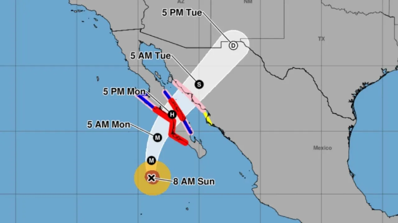
- Forecasters expect landfall in Baja California Sur on Monday, with a second landfall on mainland northwestern Mexico about 24 hours later
Hurricane Polo, an eastern Pacific system that surged from a tropical depression to Category 5 strength in only a few days, climbed back to its peak intensity on September 28, 2026, with sustained winds close to 260 km/h, as it moved toward Mexico's Baja California peninsula, according to Mexican civil protection authorities and U.S. weather agencies.584
Explosive strengthening
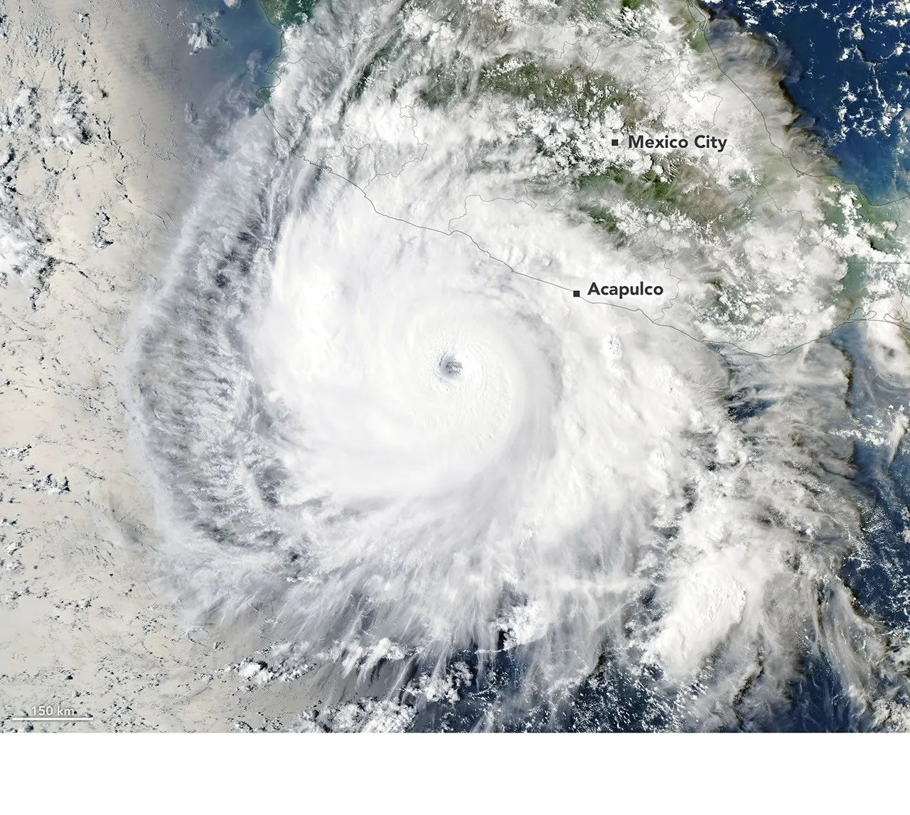
NASA said Polo underwent rapid intensification with wind speeds rising by at least 60 knots within 24 hours, a threshold meteorologists use to define the phenomenon. By September 22, according to NASA, the storm's maximum sustained winds had climbed by 90 knots in a single day, and NOAA Hurricane Hunter aircraft that flew over Polo that day estimated winds of nearly 285 kilometers per hour.21
Gary Partyka, an atmospheric scientist at NASA's Global Modeling and Assimilation Office, said conditions were unusually favorable for the storm. He described Polo's strengthening as an extraordinarily fast, almost explosive burst of rapid intensification, and said the atmosphere around the storm offered nearly ideal conditions for growth, with light wind shear, abundant moisture, warm ocean waters and strong instability all coming together at once.2
Kristen Corbosiero, who researches atmospheric science at the State University of New York at Albany, drew attention to how clearly the storm's structure showed up in satellite images. She said the storm displayed a notably large and well-defined eye along with a broad outflow pattern, adding that light winds aloft and strong venting at the top of the system helped fuel Polo's swift intensification. Officials at the National Hurricane Center went so far as to call the storm's shift "truly remarkable."27
Comparisons with past storms
NOAA NESDIS reported that Polo's winds jumped by 95 knots over a single day, making it the third-fastest intensification ever recorded in the eastern Pacific, trailing only Hurricane Patricia's 105-knot surge in 2015. NOAA additionally noted that Polo's central pressure fell by 88 millibars within a day, the second-largest such decline ever measured in the basin, just behind Patricia's roughly 100-millibar plunge.7
CBS News noted that, based on its central pressure, Polo ranked as the second-most intense hurricane ever measured in the eastern Pacific, while its wind speeds matched those of 2009's Hurricane Rick for third place in the region. CNN reported that Polo's rapid intensification of 177 km/h fell short of Patricia's 2015 record of 193 km/h, and noted that Hurricane Otis devastated Acapulco in 2023. NOAA said Polo marked the year's third Category 5 hurricane in the eastern Pacific, joining Genevieve and Lowell on that list.167
Path toward Mexico
CBS News reported that as of Saturday, Polo's center sat roughly 330 miles to the south-southwest of Cabo San Lucas, whereas the Straits Times situated the storm about 425 miles southwest of Cabo Corrientes that same morning. CBS News said the storm had eased to Category 4 as its power shifted up and down near Mexico's southwestern shoreline, whereas the Straits Times reported that Polo had climbed back to Category 5 southwest of the Pacific coast; the two outlets cited different wind speeds and positions for the same time frame.14
The Straits Times reported that forecasters anticipate Polo will reach the Baja California Peninsula while still at hurricane strength early next week, coming ashore in Baja California Sur on Monday before striking the mainland's northwestern coast roughly a day afterward. Hurricane conditions were considered possible on Monday afternoon between Punta Eugenia and Santa Fe.754
According to forecasts relayed by CBS News and the Straits Times, Polo may drop 4 to 8 inches of rain, with pockets receiving as much as 10 inches, heightening the danger of flash floods and mudslides across Baja California Sur, Sinaloa, Sonora and Chihuahua, in addition to hazardous surf, rip currents and coastal flooding. Mexico's National Meteorological Service warned that "las precipitaciones generadas por este sistema podrían originar deslaves, incremento en niveles de ríos y arroyos, así como desbordamientos e inundaciones en zonas bajas."145
Preparations on the ground
Mexican authorities suspended classes at schools across Acapulco, and Michoacán officials canceled classes through Friday in coastal municipalities, according to CBS News. Evacuations were ordered, shelters opened and troops deployed to affected areas along the Pacific coast, with port closures and beach restrictions reported in San Jose del Cabo.14
El Universal and Mexico's civil protection authority reported that 1,700 military personnel were organized for deployment in Baja California Sur, including 540 sent to Comondú, as part of preventive measures. Ports in Los Cabos and Comondú were closed to minor vessels, and nautical tourism and recreational activities were suspended on Los Cabos beaches.58
Why it matters
Polo's rapid strengthening ranks among the fastest intensification events recorded in the eastern Pacific, alongside Hurricane Patricia in 2015 and Hurricane Otis in 2023, which NOAA data classify as Mexico's costliest weather disaster. NASA linked the intensification to unusually warm sea surface temperatures and an active accumulated cyclone energy season in the basin.26
Videos
Related stories
Version history
- version 1 ·